
North Nantasket Beach Resilience
I. PROJECT INTRODUCTION
As part of ongoing efforts to build Hull’s resiliency, the Town has been working towards the goal of establishing and maintaining a continuous primary front dune along North Nantasket Beach. These initiatives build on, and are being informed by, previous efforts, studies, and community feedback.
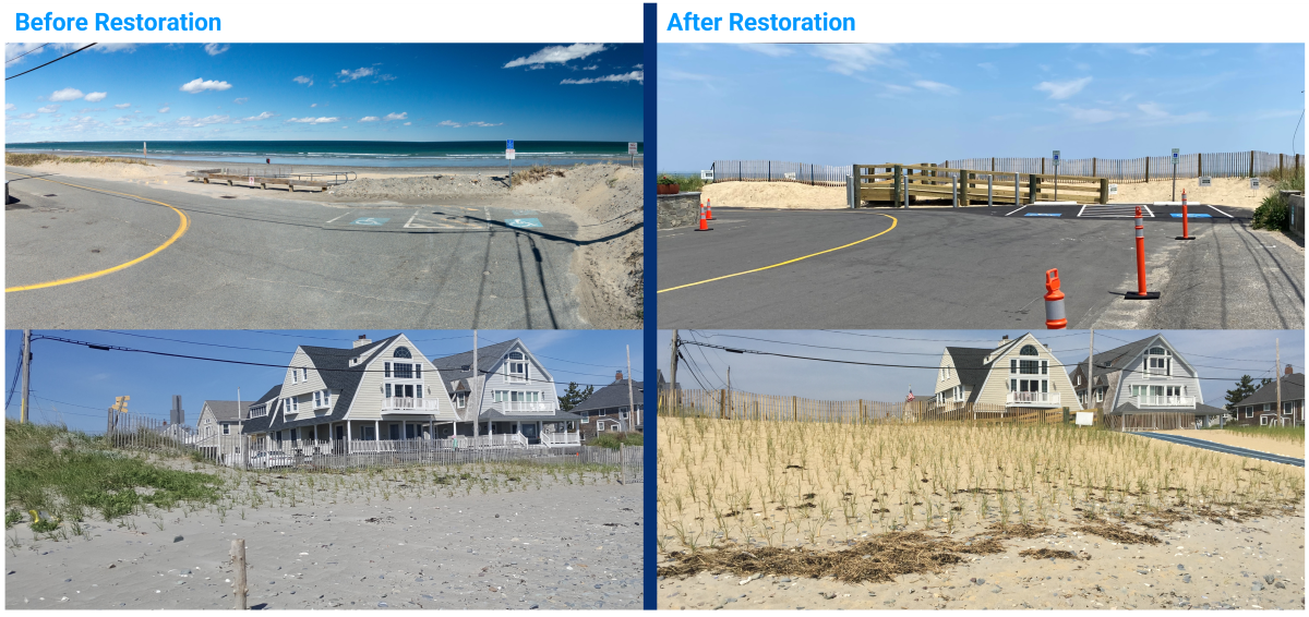
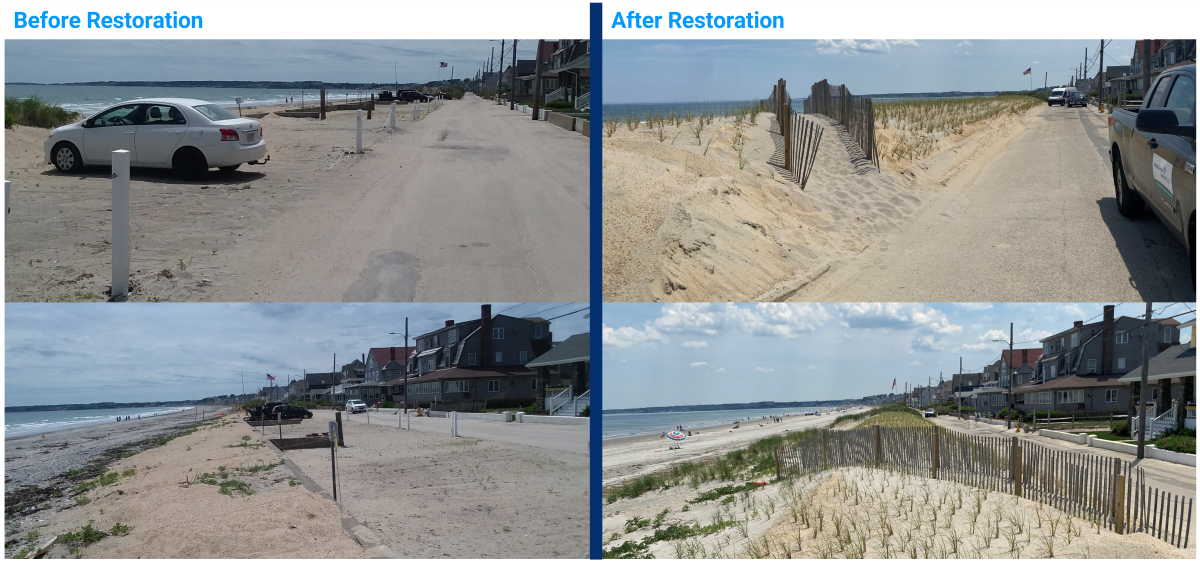
The Town recently constructed a restored primary frontal dune with an accessible crossover ramp and emergency vehicle access path at A Street and Beach Avenue, and separately constructed a restored dune and Town-maintained public access path at 131-145 Beach Avenue.
The below figure shows conditions before and after the dune restoration project at A Street and Beach Avenue (click on the picture to enlarge the image)
The below figure shows conditions before and after the dune restoration project at 131-145 Beach Avenue (click on the picture to enlarge the image)
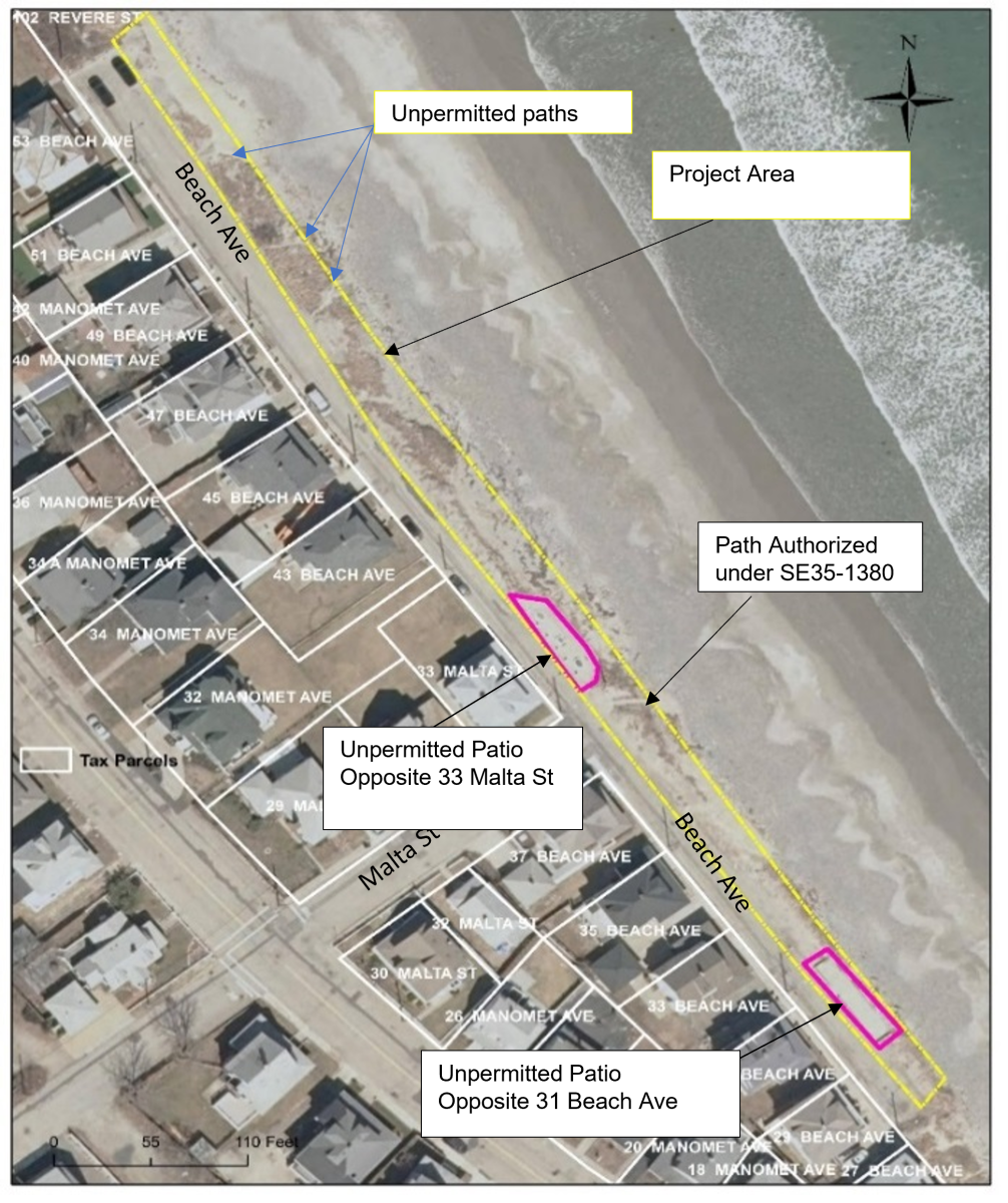
The Town is continuing its efforts focused on closing and restoring the dune at other non-permitted crossings. Currently, the Town is permitting a dune restoration project adjacent to 27-53 Beach Avenue. The project will restore degraded coastal dune habitat along approximately 800 linear feet of frontal dune to provide additional flood protection up to a 5- to 10-year return period storm. The project will also improve beach access by installing two additional Town-maintained access paths, while maintaining the existing permitted path at Malta Street. Several non-permitted dune crossings and two large non-permitted patios will be removed. The restored dune will match the height, width, slopes, and native sediment grain size of adjacent established sections of dune and be planted with native beach grass.
The below figure shows the location of the proposed dune restoration project adjacent to 27-53 Beach Avenue (click on the picture to enlarge the image)
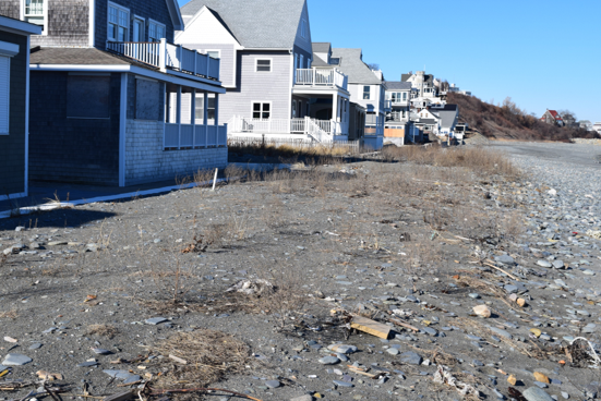
Non-permitted crossings are footpaths that beach users cut through the dune without required Town and State approvals. These crossings create significant weaknesses in the dune by not only lowering the dune’s height (and corresponding flood protection), but also by destroying beach grass which traps sand and holds the dune together during storm events. Beach and dune systems are the interface between water and land. They are by nature, dynamic environments that fluctuate in size and form due to the impacts of wind, waves, tides, and storm events. Maintaining a healthy beach and dune system is particularly important in Hull, as it is the first line of flood defense for many residents, homes, and critical infrastructure assets.
The Town of Hull’s Municipal Vulnerability Preparedness Community Resilience Building Workshop and Coastal Vulnerability Assessment and Adaptation Planning Study identified North Nantasket Beach and its dune system as the highest priority resource for adaptation to coastal flooding, storm damage and sea level rise. By enhancing beach access and restoring non-permitted crossings, the Town aims to enhance the function of the dune to protect the health, safety, and welfare of abutting residents and neighbors from the impacts of flooding and storm damage. These actions will help establish a continuous, resilient dune along the entirety of North Nantasket Beach, significantly enhancing the system’s storm damage protection benefits.
II. CURRENT EFFORTS UNDERWAY
The goal of the North Nantasket Beach Resiliency Project is to increase coastal resiliency.
- Restore the primary frontal dune at sites where it has been altered by closing gaps in the continuous dune system
- Close, restore, and prevent non-permitted dune crossings to reduce the number of weak points in the dune system
The Project will implement the following improvements:
- Restore dunes at non-permitted crossings using compatible sediment and vegetation
- Install fencing along landward edge of dune to discourage inappropriate crossings
- Install signs encouraging use of public crossings and discouraging use of non-permitted crossings
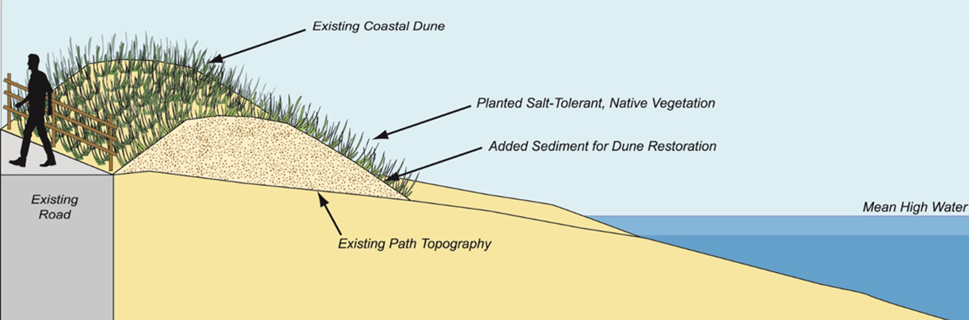
The below illustrated section perspective illustrates the proposed improvements to North Nantasket Beach (click on the picture to enlarge the image).
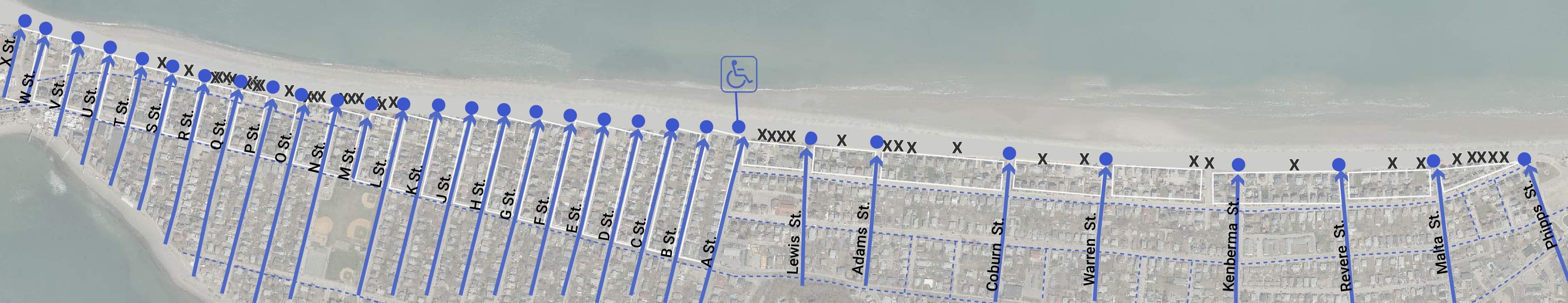
The below site plan illustrates which crossings will remain open to the public and which non-permitted crossings will be closed and restored in order to create a continuous dune system. Proposed closures do not impact walking distances to the beach, with abutting residents able to reach the beach within around 1 min or less (click on the picture to enlarge the image).
![]()
CONTINUOUS DUNE SYSTEM BENEFITS
Maintaining/restoring a continuous dune offers the following benefits:
- Provides flood protection for many families including those who live inland and at lower elevations
- Safeguards an environment that is a beautiful recreational area for our residents to enjoy
- Is a necessary component of a healthy beach and dune
- Serves as our primary line of defense against increasingly destructive storms
NON-CONTINUOUS DUNE SYSTEM THREATS
Allowing a non-continuous dune system can result in various threats to the Town, residents and the environment:
1. Flooding is a danger to life and property
2. Flood damage is costly to private property owners and to the Town
3. Flooding may hinder emergency response capabilities at a time when they may be most needed
4. Unpermitted dune crossings violate the Wetlands Protection Act
5. Weakening the dune at crossings impacts the entire beach system, its function, sediment supply, and ecological systems.
III. DUNE HEALTH
HOW THE DUNE PROTECTS
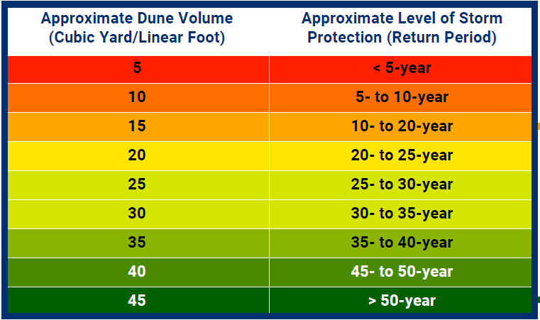
The overall volume of sediment in a dune is an important indicator of the level of protection that a dune can provide. The effectiveness of the North Nantasket dune system was evaluated based on the volume (height, width, and length) of the existing dunes. Walking on and creating crossings through the dune contributes to erosion and reduction of sediment, impacting the level of protection against storms provided by the dune system.
“Simply walking on dunes can also lead to sand-landslides that can destabilize the area; while walking on banks (particularly steep banks) can reduce their natural resistance to erosion and decrease their value as a buffer to storms.”
[Massachusetts Coastal Zone Management]
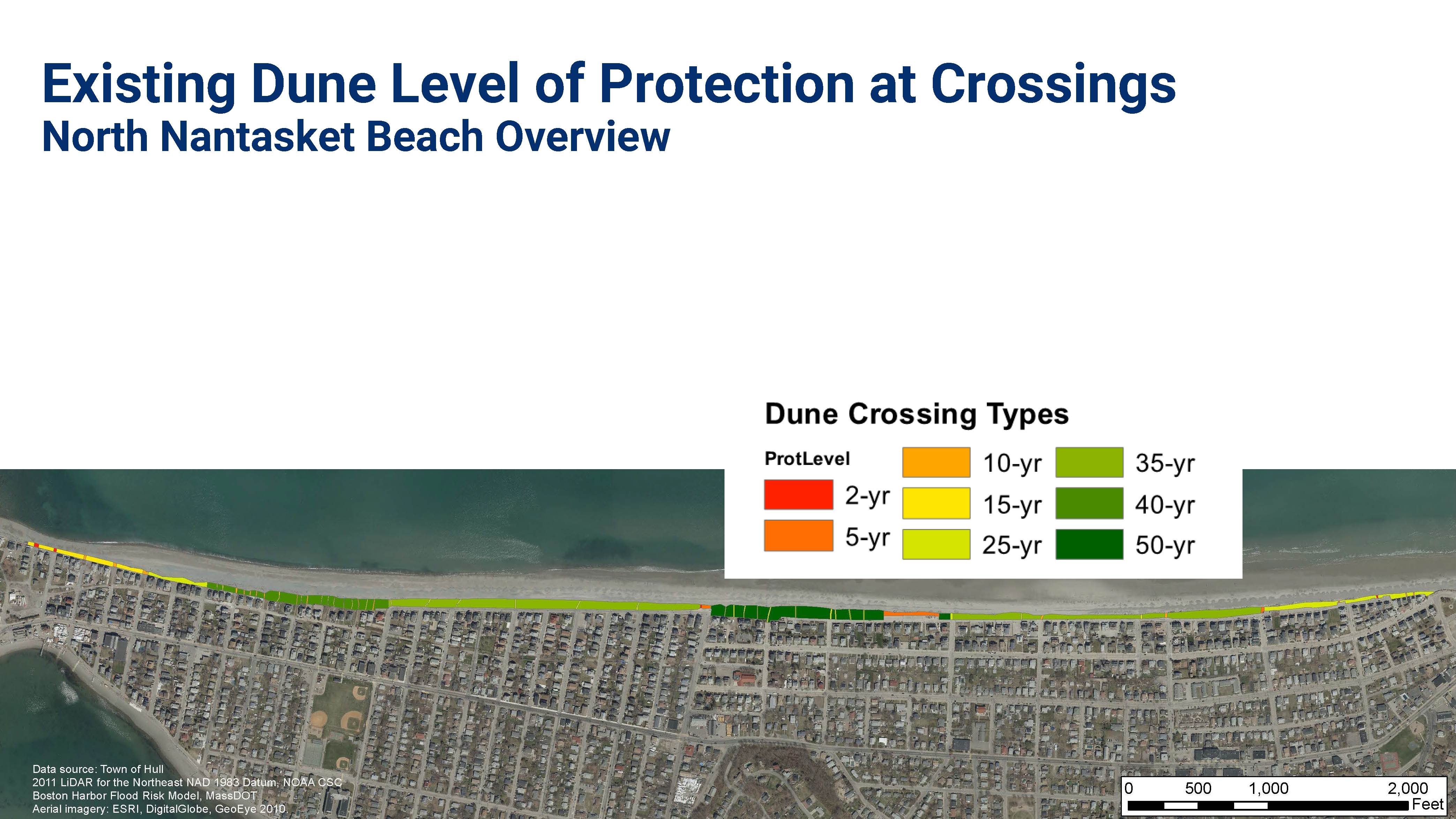
The below table and corresponding map shows the approximate dune volume and the approximate level of storm protection along Nantasket Beach. (click on the picture to enlarge the image).
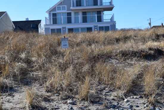
The below image on the left shows a dune with high volume (at Lewis St) versus the image on the right which shows a dune with low volume (at U St) (click on each picture to enlarge the image)
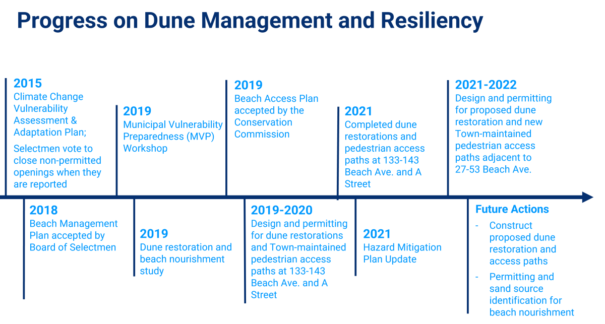
IV. PROJECT PROGRESS
The following timeline describes the Town of Hull’s actions to protect North Nantasket Beach and enhance its resilience. This project is a part of a larger initiative to restore the dune system and mitigate the impacts of climate change.
V. ADDITIONAL RESOURCES
- Enviromental Notification Form
- North Nantasket Malta Street Brochure
- North Natasket Beach Dune Project April 2022 Presentation
- North Nantasket Beach Large-Scale Beach and Dune Nourishment Planning Report -- Kleinfelder / Woods Hold Group -- 2019
- Nature-Based Solutions, North Nantasket Beach Report -- Kleinfelder / Woods Hole Group -- 2019
- Hull's Municipal Vulnerability Preparedness (MVP) Program Report
- Nature-Based Solutions on Nantasket Beach for Resilience PPT – May 23, 2019
- Nature-Based Solutions on Nantasket Beach for Resilience PPT - April 24, 2019
- Hazard Mitigation Plan - 2018
- Hull Climate Vulnerability Report - Kleinfelder
- DCR Beach Nourishment Project
- Nantasket Beach Management Plan Update Presentation - 2018
- Nantasket Dune Repair Plan
- Nantasket Beach Editorial
- Beach Management Plan FAQ
- Nantasket Beach Management Plan
- StormSmart Properties Fact Sheet #1 Artificial Dunes and Dune Nourishment
- StormSmart Properties Fact Sheet #3 Planting Vegetation to Reduce Erosion and Storm Damage
FOR MORE INFORMATION
Christian Krahforst, Director, Climate Adaptation & Conservation
Email: ckrahforst@town.hull.ma.us
Mail: Town of Hull, 253 Atlantic Avenue, Hull, MA 02045
Phone: (781) 925-8102
Fax: (781) 925-8509
VI. ACKNOWLEDGEMENTS
This project is graciously funded by a Coastal Resilience Grant from the Massachusetts Coastal Zone Management Office (CZM). The project team includes the Town of Hull, CZM, Kleinfelder, and Woods Hole Group.