
Flood Hazard Information
The Town of Hull provides a number of resources regarding floodplain management to its residents. By following the links provided on this page, residents can acquire information on topics including, but not limited to the following:
- Hazard Mitigation Plan
- The special flood hazard areas and the potential flood threatened areas of the Town
- Flood insurance and techniques for protecting property from flood damage
- Proper building techniques to protect properties and natural floodplain functions.
- Up-to-date tide information
To view the Town of Hull's Coastal Climate Change Vulnerability Assessment and Adaptation Study, click here.
If you want a detailed FEMA flood map for your property you can enter your address on this link and it will inform you on your flood hazard. If you have any questions what this map may mean please feel free to contact us for further help.
To view the changes to the FEMA Flood Map (effective December 13, 2017), click here.
Additional Links:
- Learn How to Reduce your Flood Risk
- Know Your Flood Hazard
- Elevation Certificates
- FEMA Technical Bulletins (guidance on NFIP regulations)
- Insure Your Property for Your Flood Hazard
- Filing Flood Claims
- Flood Safety
- Protect Your Property from Your Hazard
- Build Responsibly
- Protect Natural Floodplain Functions
- Guide to Flood Safety and Preparedness, National Council for Home Safety and Security
Stay Safe During Hurricane Season:
1. Hurricanes can bring heavy rains, high winds and storm surges. These result in tides swelling and high water. And, big waves can erode natural barriers, leaving coasts more vulnerable to future storms and flooding.
2. During a hurricane, if the ground can’t absorb rainwater fast enough or storm drains can’t handle the runoff, rain can lead to flash floods.
3.There are a variety of hidden risks that can put your house in danger of flooding, like new housing developments or changes in weather patterns. Flood insurance is a surefire way to protect your home, even when it doesn’t face the obvious risks for flooding.
4.Most homeowners and renters insurance policies do not cover flood damage, and flood insurance policies don’t automatically renew.
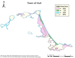
For information on the new (2024) Floodplain Management efforts see the attachments below for Hull Floodplain Map, FEMA Flood Zones, and the new proposed Floodplain Overlay District Bylaw:
| Attachment | Size |
|---|---|
| 309.69 KB | |
| 1.35 MB | |
| 518.02 KB | |
| 113.49 KB |